

Knock Knock. Who’s There? Not a Glacier, They’re Retreating
May 30, 2017
This semester, many science students have been working on their end-of-the-year science projects, and my friend Kiley and I are no exception. For our project, Kiley and I decided to analyze photographs of local glaciers taken from the past and juxtapose them with recent photographs of the same glaciers to observe the effects of climate change.
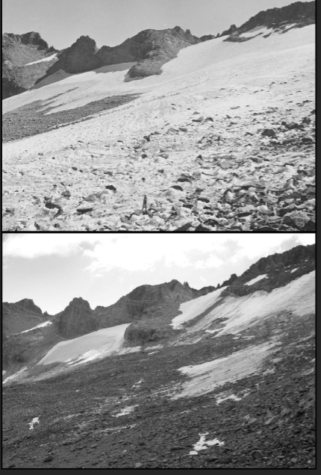
While it is common to see environmentalists on TV or on the internet warning of glacial retreat due to climate change, it is easy to neglect the danger these big hunks of ancient ice face. After all, eastern California isn’t like Greenland, covered in enormous ice sheets. However, eastern California does possess Alpine glaciers (for example, the southernmost glacier in the continental US is the Palisade glacier near Big Pine) high in the mountains. Kiley and I chose to study glaciers in local areas, such as Yosemite National Park, and the results were shocking.
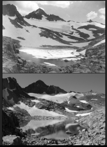
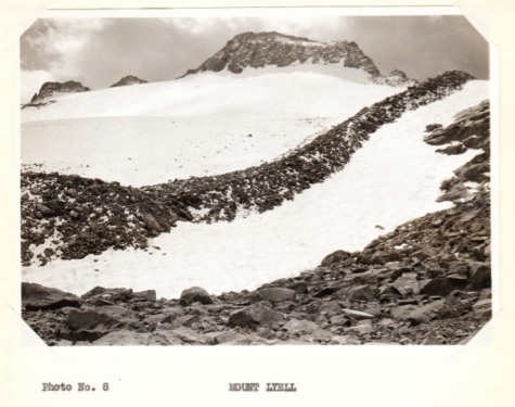
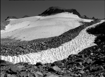
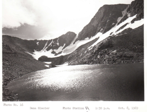
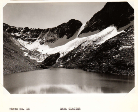
According to research conducted by Hassan Basagic, a scientist who is well-known for his glacier rephotographs, over the 101 years between 1903 and 2004, three important Yosemite glaciers have melted significantly. The surface area of Dana glacier decreased by 64% between 1903 and 2004, the surface area of Maclure glacier decreased by 47%, while the westernmost portion of Lyell glacier decreased by 40% and the eastern section of Lyell glacier decreased by 78%.
These glaciers have great ecological value. Dana glacier’s summertime runoff contributes to the Lee Vining Creek, which feeds into Mono Lake. Mono Lake relies on inlets to maintain its delicate ecosystem, and without Dana glacier, Mono Lake would be losing a valuable hydrological input. Maclure and Lyell glaciers are also the headwaters of the Tuolumne River that flows throughout Yosemite National Park. The Tuolumne River is a significant water source for many local organisms, and if its glacial headwaters disappeared, the wildlife and vegetation in the national park would be put at risk. The Tuolumne River not only encourages tourists to visit Yosemite as well, but the river also provides water to the Hetch-Hetchy reservoir, the main water source of San Francisco and much of the Bay Area. Without these glaciers, there would be much environmental and economical damage to the Sierra Nevada. Wildlife and vegetation would be negatively affected, and without the beauty contributed to by the runoff of these glaciers, tourism would certainly decrease.
Glaciers serve as an exemplary indicator concerning climate change, and, as is observed in the comparison of historical and modern day glaciers, climate change is in effect in the Sierra Nevada.


Jeniffer Velazquez • Aug 24, 2017 at 10:05 am
iconic